Feeds:
Posts
Comments

Now that I’m living in Seattle, I don’t get a chance to visit Southeastern US waterfalls very often, which is why I haven’t posted on this blog in 4 years. But when a friend of mine was asking my recommendation for Georgia waterfalls, it inspired me to do a series of review posts, of which this is the first. My plan is to highlight waterfalls I’ve visited in each region over the years (also mentioning other waterfalls in the process). We’ll start in the Northwest corner of Georgia.

Cloudland Canyon Waterfall 1

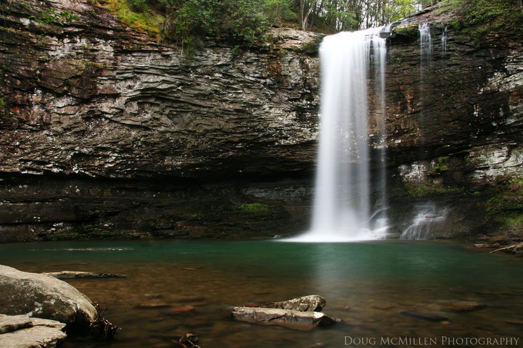
Lookout mountain runs along the extreme northwest corner of the state, reaching from southern Tennessee into Alabama. On that ridge lies one of my favorite Georgia State Parks, Cloundland Canyon. It has beautiful views, but for the sake of this topic, it has a couple of the most beautiful waterfalls in Georgia. On the Waterfall Trail you descend from the mountaintop down 1,200 stairsteps, and the above photo shows the first waterfall you Cloudland Canyon Waterfall 1 Autumnencounter. For years we’ve called Waterfall #1, though a public vote changed its name to Cherokee Falls. Regardless what you call it, it’s a beautiful 60 ft waterfall, falling into a great rock amphitheater with a splash pool. it is usually best to visit in spring, since in dry summers it often dries up to almost nothing. As you can see in the photo on the right, there are lots of photo composition possibilities around the pool. That photo also shows if you get there in autumn after a rain, it also can be a magical place.

Cloudland Canyon Waterfall 2The next waterfall you encounter at the bottom of the stairs is what used to be known as Waterfall #2, now known as Hemlock Falls. It is a beautiful 90 ft waterfall, also falling into a nice rock amphitheater. Photographically possibilities are more limited because the state park built a very nice viewing platform, not wanting people to injure themselves exploring elsewhere, and that limits access. This is the end of the Waterfalls Trail, but it isn’t the end to waterfalls at Cloudland Canyon. The end of the Waterfalls Trail is the start of the Sitton’s Gulch Trail, which continues down from here along Daniel Creek for another 2 miles.

Cloudland Canyon Waterfall 3ARight at the start, it passes by two smaller waterfalls (not officially named by the State Park). Scott and I named them years ago Waterfall #3A & #3B, given they are in quick succession, and not as tall as the first two. The first fall (#3A) is a 20 ft drop, and very photogenic, with composition opportunities all around it. Cloudland Canyon Waterfall 3B AutumnThe second fall here (#3B) is a small ledge drop of Daniel Creek right after the pool for #3A. But what it lacks in height, it makes up for with composition possibilities from different angles, two photos of which I included here (from different angles and seasons).Cloudland Canyon Waterfall 3B 
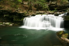
There are also other seasonal waterfalls at Cloudland that you might find; but for now, I’ll leave you with the main falls.


Lulu Falls' BaseThe next area that I’ll mention is also on Lookout Mountain, in land owned by the Lulu Lake Land Trust. The land is open to the public usually on two Saturdays a month. It has trailsLulu Falls and the beautiful Lulu Lake (and the small Lulu Lake Falls going into the lake). For today’s discussion though, it also has the very impressive Lula Falls, where Rock Creek pours over 100 ft straight down. This waterfall is similar in style to the main two waterfalls in Cloudland, pouring over the escarpment into a large rock amphitheater. It doesn’t have the pool at the base like the Cloudland falls, but you can walk all around it (and even in the fall), as you can see from the large photo above.

There are also other waterfalls in this far western part of the state, the most famous of which is Keown Falls, managed by the Forest Service. It is extremely low-flow, so I’d recommend it only in spring after a good rain; I haven’t captured a good photo of it. But my blog partner Scott did a blog post here where he captured Keown Falls, Little Keown Falls, and another in the area called Pocket Falls.


A little further to the east still in far north Georgia is the vast and beautiful Cohutta wilderness of the Chattahoochee-Oconee National Forest. Barnes Creek FallsThe area has 90 miles of trails deep into wilderness, on many of which you will encounter few people the entire day (one day I saw more wild boars than people). There are also many waterfalls in the Cohutta, but most of them I haven’t been able to visit. The most famous waterfall in the Cohutta is the 80 ft powerful Jacks River Falls. The classic hike to get to Jacks River Falls is epic, requiring an 18 mile (round trip) hike with 20 river crossings. I still would like to try that sometime, but I have not yet.

But there are other waterfalls in the Cohutta I have visited. One roadside fall is the 15 feet Barnes Creek Falls, part of which is shown on the right. The Forest Service has a picnic area by the waterfall, and it’s worth stopping when in the area.

Both times I have stopped by Barnes Creek has been on my way to other waterfalls in the Cohutta, hiking to Panther Creek Falls. Panther Creek is tough to access, with two options requiring either a long hike with a ridiculously steep drop to get to the top of the Pather Creek Falls 1fall (the direction we went) or many waist-deep stream crossings. The day we went there was dense fog, and it was so beautiful that the grueling hike was worth the effort. Panther Creek Falls itself is a huge 400 ft tall waterfall. But it’s difficult to get a view of it all since it’s deep in wilderness with no viewing platform–and the day we were there it was too foggy to see all of the fall. So I contented myself with photos of sections of it, as in the photos to the left and below. Here’s a link to a photo by Mark Morrison that shows the main drop. There are also many other falls in the Cohutta, and most hiking books have descriptions how to get there. And hiking in the Cohutta is a worthy adventure in its own right.

Pather Creek Falls 2

So there you have 3 places in northwest Georgia (and a 4th if there’s a lot of rain) that are great locations to explore waterfalls. Once spring starts soon, I expect you all who now live nearby to get out and explore some waterfalls!

Little River Canyon

Water Levels Update: still has been lots of flow for normal spring (though not extremely high levels).
Spring Greenery Update: Lots of wonderful greenery in the southern Appalachians.

Two weekends ago, I went to a balloon festival in Menlo Georgia, close to the Alabama border. So I decided it was time for a quick trip (1/2 hr) over the border to the Little River Canyon in Alabama. It’s a large canyon (the largest east of the Mississippi) that is managed by the National Park Service. Years ago, when I would drive between Atlanta and Huntsville, I would drive through here, amazed by the beauty here and admire the Little River Falls (even snapping a quick shot of them). So I figured it was time to stop by again at the end of the day, hoping to capture the waterfalls before sunset. I first stopped by the Little River Falls themselves, the most impressive falls of the area, but because of people there, I decided to return right before sunset.

I decided to stop first at a small waterfall I had learned about earlier in the day when exploring on the web. It was supposed to be on a little tributary (Wolf Creek) of the Little River, and was supposed to be rather rain-dependent. Since it rained recently, I gave it a try. It actually is a two step waterfall, known generally on the web as “Gregg’s Two Falls.” It required a short (0.3 mi) hike down along Wolf Creek from the road, following a faint trail (sometimes following my nose than a trail), down to the first step, the upper falls. I was really amazed by this, such a beautiful setting:
Upper Greg's Two Falls
It was really photogenic to me, with the many stair steps, and this time of year, with the greenery and the azaleas and mountain laurel around. Lower Greg's Two Falls After enjoying this for a while, I then descended 0.2 miles to the next step, down to the lower falls. The lower fall is small, but in a very nice bowl of rock, with a rock wall to the right of the photo you see here. It was funny that I had the place to myself, but I suddenly heard what I thought was someone talking while I was there; after searching, I realized it was a mother duck calling to her ducklings to get close since I was there. I also really enjoyed this setting, such a beautiful pool and rock setting, but eventually fought my way back up to the road to continue waterfalling.

Next up was Grace’s High Falls. Grace's High Falls It is likely felt to be the highest fall in Alabama, being a 133 ft seasonal waterfall that pours off the side into the Little River Canyon. You can view it from a viewpoint across the Bear Creek side canyon, from a viewpoint from the state highway that runs along the Little River Canyon (AL 176). Though it is tall, it isn’t very impressive to me, so after getting some shots of it, I took off back to Little River Falls before sunset, since the sun was getting very low in the sky.

The waterfall on the Little River itself is one of Alabama’s best–though really only it’s impressive in spring, when it’s really raging. In summer, it has much less water. Little River Falls It has area where you can climb up to the fall–and though there are signs telling to not jump off the falls, there are no barriers to prevent it, so watch young children. This access is great for people to enjoy the falls–but also makes it very popular, which can be difficult for waterfall photography, to not have people in your shot. But when I came back this day before sunset, I had the place to myself, able to come up with a few different shots I like, showing it off and decent (but not very high) spring water levels. However, as you can see, the colors were starting to shift to the more blue end of the color spectrum, only some of which you can easily correct in photoshop without making it look too strange. I enjoyed just sitting in front of it, eventually deciding it was time to go back, finishing a successful waterfalling day.
Little River Falls Closer

Water Levels Update: normal spring levels currently, so get out there and enjoy waterfalls!
Spring Greenery Update: Wonderful spring greenery (in Georgia at least).

I took a trip this past weekend going up to Moccasin Feeder 1Moccasin Creek, near Lake Burton and before the creek flows through Moccasin Creek State Park. I thought I’d try to get to the Upper Falls on Moccasin Creek, which eluded us on my first trip here; and though I didn’t make it there again, this time it was because sometimes the journey is more important. On my way to the trail head, at Lake Burton I encountered evidence of the dramatic destruction a F3 tornado did to over 100 houses by the lake, a tornado I hadn’t heard about (obviously the news was then dominated by the more deadly tornadoes the same day in Alabama). After passing by that, amazed, I started the Hemlock Falls Trail, following cascading Moccasin Creek. I’d been along this trail before, but that time the sun made it such that I didn’t get any decent photographs. The trail easily goes to Hemlock Falls in just 1.1 miles, passing 4 other small falls along the creek before it. Most visitors stop there, but the the trail continues up to Upper Falls, though it requires wading the creek to get there.

This time, I waited until late in the afternoon–so the sun would be hidden from view–and I was rewarded with wonderful photography conditions. The first waterfall I encountered was for a small feeder stream into Moccasin Creek, a nice delicate 15 ft fall (see in the photo above). Then shortly after that was the first drop on Moccasin Creek itself, a 10 ft slice through rocks, which I thought was in a really nice setting, and I was here for quite a while taking photos. The spring greenery really jumped out for me this day (as you’ll also see also for the other photos today). Moccasin Creek Falls 1

Only another 0.1 miles up the creek, there was another 10 ft waterfall, but it didn’t look as photogenic to me, Moccasin Creek Falls 3I knew I was losing time, and it required bushwhacking to get to it, so I passed it up this time for greener pastures. That didn’t take very long, since in another 0.1 mi, the next drop occurred, a 10 ft two-step drop that is right before a bridge on the trail crossing to the other side of the creek. Like the first fall, it only required a minimal off-trail scramble to get to it, but I’d only recommend it if you don’t mind risking getting dirty in the mud.

The little falls were coming Moccasin Creek Falls 4quickly now, and again in only another 0.1 mi was the next waterfall, a roaring 20 ft drop. It was actually causing some spray, though I was able to keep my lens dry–and I didn’t slip on the wet rocks, like I did last month at Crow Mountain Creek. I didn’t find this waterfall quite as photogenic, though it was a nice setting, and again the greenery was beautiful around it. However, I did find Moccasin Creek right above this fall really beautiful with many different rock textures and pools: Moccasin Creek

Back on the trail, I was on my way to Hemlock Falls when I thought I heard the sound of a waterfall nearby. Moccasin Feeder 2I followed my ear through an empty campground to a 100+ ft waterfall from a feeder stream. It was pouring down the hillside that created the canyon for Moccasin Creek. This waterfall wasn’t listed in any book I knew of, including a waterfall hiking book that listed the first feeder stream (up top of this page). I’m sure that it is very seasonal–though with the rock base for it, it seems to run somewhat frequently. It was quite striking to see for its height, and it pours immediately into Moccasin Creek, as you can see in the photo.

After this slight detour, I made it finally to Hemlock Falls, which I had to myself (unlike last time with a lot of kids swimming there). I captured photos of it; however, it was getting dark enough that colors where shifting such that I couldn’t get as appealing of a photo as the previous falls (I did what I could with Photoshop to correct colors for the shot below). So even though I had wanted to make it to the Upper Falls, I felt like I saw so many falls this day–and spent so much time photographing them–that it was okay not making it there. Next time I will make it there! But in the meantime, I enjoyed Hemlock Falls, and then journeyed back to the car before sunset.
Hemlock Falls

Tallulah Gorge in a Fog

Water Level Update: good spring levels in north Georgia (not extremely high, but good levels).
Spring Greenery Update: Greenery is good at least up to 2500 ft in Georgia (I didn’t go higher this weekend).

This past Saturday, I woke up to Atlanta being extremely foggy, and the forecast expected it to be cloudy in north Georgia through at least the first half of the morning, so I took off for north Georgia, deciding to visit the Tallulah Gorge.Tallulah Gorge Foggy The Tallulah Gorge was one of north Georgia’s first tourist attractions, one of many areas that over the years have been dubbed the “Niagara of the South.” It’s a gorge created by the Tallulah River, which is over 800 ft at its deepest. It first became popular in the late 1800s due to railway being built to it, and was extremely popular until dams were built upriver of it in the 1910s. The completion of the dam in 1913 dramatically cut the water flow, and the tourists disappeared–until it became a State Park in 1993 (though still not to the levels pre-damming). Now for 4 weekends a year (except when in a drought), the park does “aesthetic flow days” where they release much more water so it rages more like it did years ago. The photo above only shows part of the gorge, but somewhat shows its size.

As it is now, “Tallulah Falls” is a series of 5 falls. L'Eau d'Or Falls You can manage to see most of them from viewpoints around the gorge, but the best way to see them is to descend into the gorge. As you do so, the first you encounter is the first fall in the series, 46 ft tall L’Eau d’Or Falls. As you can see, this day it was wonderfully foggy, which I think was great for the waterfall shots. This view is from an easily accessed viewing platform, which you will likely not have to yourself (unless it’s early in the morning on a foggy day). 🙂 It also is a great place to see with autumn colors.

From there, to get to the bottom of the gorge, you have to descend 1062 steps (crossing the gorge midway on a suspension bridge) to the base of Hurricane Falls. Along the way, you pass by 76 ft Tempesta Falls, and you can see part of it, but there isn’t any great view of it from there–only from the top of the gorge, as I did later. 96 ft Hurricane Falls, with its pool after the water explodes around a bend in the gorge, is quite impressive to see. The viewing platform here is where the staircase ends. Hurricane Falls From there, you can hike on the canyon floor if you get a permit from the state park. Your have to boulder hop across the river, then there is a trail to the next fall in the series, 50 ft Oceana Falls. Tempesta Falls I did this trip with some friends 3 years ago, and we made it also to the final fall, 17 ft Bridal Veil Falls, which is also known as “Sliding Rock Falls,” implying you can slide down it, which we all did. But I didn’t do that hike along the base this day.

Instead, I wanted a good photo of Tespesta Falls, since I didn’t have one yet. So I gave my quads a good workout up those steps, and then around to the other (south) rim of the gorge. From there I came to a nice viewpoint where you can see Tempesta Falls from a distance (again, this day with fog hanging over the gorge). It was good to get a photo of the fall, but really experiencing it from afar isn’t as impressive as being nearby them in the gorge itself.

Caledonia CascadeMy final goal for the day was to capture a photo of the Caledonia Cascade. It is a 600 ft waterfall, which pours from a feeder stream down the side of the gorge. It’s a low-flow waterfall, as you can see in the photo I took from across the gorge, even in spring, and often is almost non-existent later in the year. Much of it can’t be seen from the other side due to tree cover, and as such, this photo only represents around 1/4 of the full height of the fall. It’s funny–sometimes books or websites obsess over which waterfalls are the “tallest,” implying that’s automatically the best. I think this is a good example of how it’s not always the case; though this is one of the tallest waterfalls in Georgia, it certainly isn’t one of the “best,” at least in my opinion. Even though the cascade wasn’t impressive, the Tallulah Gorge was, and the weather on Saturday was great for photography and waterfalling.

Return to Blood Mountain

Water Flow Update: good water flow in north Georgia, especially since there have been lots of recent rains.
Spring Foliage Update: foliage decent up to almost 2000 ft in Georgia, above that just starting (dogwoods, etc, but not greenery).

Blood Mountain is the 6th highest mountain in Georgia (at 4,458 ft), and the highest point of the Appalachian Trail in Georgia, surrounded by a great wilderness area. It has a wonderful view from on top of it after a great (though steep) hike. And being high, water flows off it steeply, so there are a number of waterfalls falling from the sides of it. Both Scott and I (at different times) had visited some of these waterfalls, but there were more we hadn’t hit yet, so that was the plan for this past Saturday morning. Another part of the motivation was that I had a copy of a nicely done new book of hikes to Georgia waterfalls, Waterfall Hikes of North Georgia, by Jim Parham, which described hikes to these waterfalls.

The first waterfall was Crow Mountain Creek Falls 1Crow Mountain Creek Falls (we passed by Dick’s Creek Falls, which we both had photographed before, and there were a lot of fishermen there). Around 3 years ago, I found out about this waterfall, only finding one photo of it on the web. So I tried to find it, bushwhacking up the creek for 1 hour before giving up–on the way back, I came across the trail to the falls, but without time to go back. So I have wanted to visit these falls to see them for a while. We followed the book’s directions, and followed a old logging road up for 1 mile up to the top of the falls, and were definitely impressed by them. They are a series of multiple cascades and slides that descend for more than 100 ft. The only problem is that there wasn’t really a great viewpoint to photograph these falls well. The first photo here I actually fell on the wet rock getting into position, and dropped the camera, though it has (thankfully!) been working well since then–thanks for being weather resistant!

Crow Mountain Creek Falls 2We continued down the side of the mountain, trying to find a viewpoint of the falls that really displayed how impressive they are. Toward the bottom of them, I found this vantage point, which I had to climb onto a bunch of downed trees to get into, but I think gave the best perspective I could find. The falls in first photo are all in the uppermost part of this second photo, just to give you perspective on the size of it. Though we had to admit they aren’t the most photogenic falls, it was a very cool waterfall to see (finally for me!), and the sun stayed away enough for photography. So mission #1 for the day was accomplished.

The next task was to get to Upper Blood Mountain Creek Falls. Both of us have previously been to Milddle and Lower Blood Mountain Creek Falls, but not the upper falls. Pool Below Upper Blood Mountain FallsWe used a higher-clearance vehicle to cross Crow Mountain Creek, and drove to the end of the road at the entrance to Blood Mountain Wilderness. Then it’s a easily-followed trail for 1 mile (the last 1/2 of which along Blood Mountain Creek) to the upper falls. At the base of the upper falls was this beautiful little cascade into a nice pool Upper Blood Mountain Creek Falls on the right, really showing off the nice setting here. Then you have to climb a little up a bolder field to get to the base of the upper falls, the main drops of which are around 40-50 ft tall. As you can see in Scott’s photo, the water spreads over a rock face, then takes a sharp right turn down the mountainside. We sat and just enjoyed the setting for a while, then returned back up the final hill to the car.

There was one final stop Upper Dick's Creek Falls this day, which was a “bonus fall” that we didn’t know before existed, Upper Dick’s Creek Falls. We saw it right beside the road to Upper Blood Mountain Creek, but visited it on the way back, especially since there were fishermen there the first time. We stopped by and visited this nice little 20 ft fall as the finale for the day. It was not an amazing fall, but required no effort to get to, and still has the wonderful brown creekbed color I love in north Georgia. Visiting 3 waterfalls that I hadn’t seen before made this definitely a successful day!

The title is in followup to Doug’s previous post about a waterfall we checked out last weekend in Gwinnett County. The waterfall that you see in this post I visited the previous day from our Gwinnett waterfall visit.

The name of this waterfall is High Shoals Falls and is found in the heart of Paulding County. If you aren’t aware Paulding is the county directly west of Cobb County. The waterfall itself is a 10 minute drive north from downtown Dallas. From Dallas you have about a 30 minute drive to back towards Marietta.

I came across High Shoals while talking on the phone with Doug discussing a new blog he had run across. The blog is about waterfalling around Georgia. While discussing with Doug about some of the falls the blogger had visited I came across another mention of a waterfall north of Dallas and so opened up Google Earth to see if I could find anything about it. As it would happen I found two pics from Panoramio on the waterfall from Google Earth (you would be surprised how many times this happens).

The next Saturday I decided to drive out to Dallas and see if I could find and visit the waterfall. It seemed like a pretty easy find and hike, so I didn’t anticipate any problems.

I arrived at the cemetery mentioned in the directions and where I was supposed to park my car. The area was small, for like maybe 4 or 5 cars. There was a sign showing the park hours (I forget what it said specifically). I grabbed my gear, my dog Sally, and headed down the trail.

The trail was a short 200 or 300 yards down the trail. The area is very unassuming and quiet.  You can hear the waterfall not far after you start down the trail. Once you arrive the waterfall faces you on the trail and makes for a really nice scene. The first picture above is what you see as you arrive.

What is really cool about this waterfall is that it is so out of the way, and so unknown, that chances are you will have the place to yourself. The flow of the creek and shape of the contours of the land are seemingly perfect for shots from either side of the creek that flows down from the waterfall. The rock face that the falls tumble over create a small amphitheater and climbing to the top of the falls from either side is relatively easy. The falls spill into a fairly shallow splash pool and give way to some small cascades just beyond the pool. Overall all I have to say this might be the most accessible waterfall I’ve ever been to. The only unfortunate thing about it I would say is that beyond this place there isn’t really anything else, waterfall related, beyond a good 30 to 45 minute drive.

Technically speaking I had to do some filter stacking with the sun conditions. It was basically late morning (noon-ish) so the sun was nice and high in the sky. My 8x ND filter and polarizer worked out well. I shot multiple exposures and processed with exposure blending to get the results you see here. The panoramic below was from 5 frames, taken from left to right, with 3 exposures each. It is simply amazing how good Photoshop has gotten now with merging for panoramics. My suggestion would be to hit this waterfall later in the day or early morning. If you live in the Atlanta area I would certainly recommend checking out this waterfall…. it is worth the out of the way trip.

Don’t forget you can find the location of this waterfall and many others throughout the Eastern US via our waterfall database.

Water Levels Update: typical spring levels currently, depending on recent rain.
Spring Color Update: still not much to speak of above the Piedmont (and barely any there).

There were two water towers that were seen along Interstate 85 in Gwinnett County in the Atlanta metro area–which I often passed going to north Georgia for waterfalls. One of the towers said “Gwinnett is Great,” and is the reason for the title here (the towers were taken down last year). Scott & I decided to take advantage of perfect early spring weather, and visit some waterfalls we learned about in another blog I found recently from someone else who is visiting local waterfalls. Based on her description, we decided to check it out, especially since they weren’t far away.

Freeman’s Mill Park is a relatively new Gwinnett County Park the primary goal of which is to preserve a historic grist mill. Freeman's Mill Dam FallsThe mill looks nice, though it isn’t yet restored inside; however, we were interested in the waterfall nearby. There was a man-made fall created by overflow from the former dam for the mill. Though I tend to prefer natural falls to man-made, it was a nice setting, looking appealing even with full sun on the scene (usually not great for waterfall photos), and filters allowed me to get a long-exposure shot that I was pleased with.

Alcovy Lower FallsBoth of us had seen a few posts about the area, and knew there was another waterfall there, which we saw across the creek. We got across to it, and checked it out. I would be careful about this, since I don’t know about access to this, though there were no posted signs around telling of it being private. There we came across another waterfall, almost 20 ft tall, a nice sloping natural fall. Again sun made it difficult waterfall photography conditions, but I think Scott was pleased with this shot. I think this setting in spring greenery–and on a day with even lighting–could be really beautiful for waterfall photography. We looked around the area, and Scott had heard there was an upper waterfall, so we continued up beside the fall to explore further.

Sure enough, we came across the upper fall after a few hundred feet of mostly walking along the creekbed (once above the lower fall). Alcovy Upper Falls This fall was really impressive, and more dramatic than we expected it to be, being more than 30 ft series of steps. It also had really beautiful rock colors. However, the sun really did a number on any photo that was taken of it, providing way too much contrast. Again, I think that with spring greenery, flow, and even lighting, this could produce a really amazing waterfall shot. We’ll just have to come back later in the spring to try…

Flood Warning Waterfalling

(though it’s early in the season, I thought I’d start adding spring season updates)
Water Level Update: lots of water currently on falls in north Georgia
Spring Greenery Update: no greenery (not surprisingly) in north Georgia yet.

There was a lot of rain over this weekend, and actually in NE Georgia there was a flash flood warning on Sunday. I’ve been wanting to go waterfalling, so I thought it would be perfect chance to visit some normally low-flow (and easily accessible) waterfalls with lots of water on them. I convinced fellow waterfaller Scott to join along, and we went to Rabun County (Georgia’s home to the most waterfalls) to explore. (disclaimer: you have to be careful waterfalling when creeks are at flood stage, and make sure you know what you’re doing. We chose carefully what falls we visited to not get in trouble with mother nature.)

Our first stop was Ada-Hi Falls (sorta) in Black Rock Mountain State Park, to visit the highest altitude waterfall in Georgia (well over 3000 ft elevation). It is a very small drainage, so it is often only a trickle (as it was last time I tried visiting it 3 1/2 years ago, as you can see on the right–though that was autumn, so it should be expected). For that reason, I hadn’t gone back for these years–but I figured flood stage today was the perfect time to visit it. As I mentioned, it’s in Black Rock Mountain State Park, and is a very steep but short <1/2 mile trail to the fall from nearby the campground general store. The trail was a little slick but not difficult, and has Ada-Hi Falls stairs for the very steep sections.

Wonderfully, today there was a lot of water going over the falls, and it looked really beautiful, as you can see (it even had some light fog around). Because of steep terrain around, there is a viewing platform, which significantly limits your photography composition possibilities, but it was still great to photograph it. So if you’re waterfalling nearby and there has been a lot of rain recently, I’d recommend it–otherwise, I’d skip it and visit other waterfalls, since it is admittingly very rare that it looks this beautiful, and there are a lot of wonderful waterfalls in Rabun County. Both of us also really liked the rock texture the water poured over (see below).
Ada-Hi Close-Up
The next stop was in Warwoman Dell, where I visited in a previous post. As I mentioned in that post, there is a small waterfall in the Dell itself, but because it was only a dribble, I didn’t photograph it that time. So again, I thought that with very high water levels, it was perfect time to capture that waterfall. We stopped by the Dell, Warwoman Dell Falls and climbed up 44 old (and mossy) stone steps. There, we came to a previously planned railroad bed; here is some history of the Dell, including about the proposed railroad. The top stone steps actually had water pouring down them, and at the top we were treated to this small but pretty waterfall (and a flooded trail). The photo here shows the waterfall with the railroad bed on the left. The sun now appeared from behind clouds, and it limited what we could do photographically with this waterfall.

Since the sun was now out, it put a damper on our waterfall photography for the rest of the day. We did explore some, finding some waterfalls we hadn’t found (or seen photos of) before–one of which we knew had to be there, though it was good to actually find it. …but that’s for another day, once we’ve explored them more fully. For me, it was great to spend time waterfalling for the first time in months, getting ready for the upcoming waterfall season!

Blue Ridge Waterfalling

Wow! It’s been forever since I’ve done a blog post. I just received a notice from WordPress that our blog had 1300 views in the past year–which surprised me, but also made me feel guilty about not updating in 6 months. What’s been going on? I’ve been waterfalling (as I think Scott has some), but it mostly hasn’t been in the Southeast US (low water levels lead to not as good waterfalling), so I didn’t post it here. In the summer, I visited the upper Sierrra Nevada and Lake Tahoe region, seeing around 10 waterfalls; and in autumn I visited New Hampshire and Vermont, seeing 20 waterfalls. But there was one more trip this past year that would qualify for this blog, so I figured I’d start off the new year right, with a post!

Since it’ll soon enough be waterfalling season here in the southeast, be ready for more posts soon (as well as like last year, updates on conditions during spring). If you have any other ideas to improve the blog, let me know!

—–

I hadn’t done any waterfalling with Scott (the co-author of this blog) for months, so we took off for Labor Day weekend in September up to North Carolina, mostly along the Blue Ridge Parkway. It was a wonderful weather weekend, comfortable temperatures and sun, but that didn’t make for a good of waterfall shots…

The first stop was the Rainbow FallsHorsepasture River on our way up to the Blue Ridge. The Horsepasture is an amazing wild river (which undoubtedly deserves its own post in the future) with multiple waterfalls, but this time we only visited Rainbow Falls. Rainbow is one of my favorite NC waterfalls, with its amazing wild setting, being able to access it, and being a powerful 125 ft waterfall. Also the first time I visited it was in autumn of 2007, when I had the fall all to myself, with a radiant foliage display. This time wasn’t quite as breath-taking, but it’s still an amazing fall. Since I visited it then, access to it has changed, now accessed from the new Gorges State Park. A good description of access is on Waterfall Rich’s site. The new trail to Rainbow is easy enough (3 miles round-trip); and after sunset, we came across a black bear on the trail on the way back to the car (though no photos of it). We spent a while photographing Rainbow Falls from multiple angles, but this was the photo I liked the best.

Crabtree FallsThe next morning we started off on the Blue Ridge Parkway, and the fall we visited was one I’ve wanted to see for a while, Crabtree Falls. It’s a popular stop on the Blue Ridge, with its own recreation and camping area. As Rich describes, it’s a 2 mile loop to the waterfall, descending on the way to it–so climbing back up. I really loved this waterfall–it definitely did not disappoint in seeing it. It’s an amazingly photogenic waterfall, with the curtain of water over many steps, and a nice setting. However, as you can see in my photo, there was a lot of sun, and with the partial tree cover, it made a good shot impossible. I definitely need to return when there are better photo conditions.

Our next stop on the Parkway was Linville Falls. It is also a signed stop off the Parkway, with a visitor center, and was INCREDIBLY crowded. I guess that’s what we get for going on a holiday weekend! 🙂Upper Linville Falls I had been here before, and like then, I went away not too impressed. It’s not that it’s bad, but for being as famous and popular as it is, I guess I expected more. I’m sure that on a different day, not fighting crowds on the trails, that I might feel differently. The first stop was Upper Linville Falls, a few feet double drop, which I liked better for the setting than the fall itself. We continued Linville Fallswith the crowds along the path to the view of the main fall, but I didn’t get anything that appealing from the viewpoint. The better view was from another trail (without a sign denoting the trail) that starts from the visitor center, runs along the other side of the gorge, and descends to the base of the fall. There you can climb around on the rocks below the fall, and there were many different angles for photography. It was much more enjoyable an experience there than above. As you can see from the photo, there was a lot of sun while we were there, but with my 8x neutral density filter (and a polarizer), I could manage a long exposure to get a decent shot.

We finished off our full day along the Blue Ridge with a stop at Mount Mitchell, the highest point east of the Mississippi. We also hiked a very pleasant trail over to Mount Craig, the second highest point. There were no waterfalls there :), just beautiful views of the southern Appalachians: Mount Craig

The next morning we first visited Graveyard Fields area off the Parkway, a high-altitude flat valley. It’s very popular for hiking, but being early in the morning, we didn’t have too much of a problem with crowds. There are 3 major waterfalls there, but given low water levels, we only visited one, Second Falls. It’s a short (1/3 mile) hike down to Second Falls from the parking lot (so we figured even with low water levels it would be worth it–I’m very glad we did). The falls is on Yellowstone Prong, and given the rock color, I can see how it got its name… Though we had to deal with lots of sun, I was actually pleased with how the photo turned out, the sun allowing me to bring out the vivid colors.
Second Falls

Then as we left the Parkway to head back toward Atlanta, we drove down Highway 215 and stopped by one last waterfall, Courthouse Falls. I think it ended up being my favorite of the trip. It goes to show that it isn’t the tallest or most powerful, but the overall presentation that really appeals to me with many waterfalls. It took just 5-10 minutes to hike to it, but we had it all to ourselves, and it was in a nice rock amphitheater. It was hidden from the sun, so I could finally get a waterfall photograph that I really liked from the trip–it only took until the last one! But now I have an idea of some places to re-visit with better waterfalling conditions (and it was great to get out and do some hiking).
Courthouse Falls

I know this isn’t in the Southeast, but I thought I’d do a blog entry from a trip from last month. See, in the Southeast, we’ve moved into summer, so it’s getting so hot that the hike to waterfalls becomes less appealing (though swimming in them is appealing). Therefore, waterfalling trips are becoming less, and and it’s time to remember the spring…

Last month I Clifty Creek went to Indiana and Ohio for a weekend, for a friend’s wedding and Mother’s day, respectively. On the way, I stopped by Clifty Creek State Park, in Indiana. It’s a beautiful park, with 4 impressive falls (well, impressive in spring). There are views of the falls (partially obstructed) from above, but the best views are in the creek itself. Big Clifty Falls I creek-walked (above) to Big Clifty Falls, the most impressive of the falls. The park restricts access to the base of all the falls, so this was the closest I could get. It’s a very impressive 60 ft curtain fall. I also tried to visit Little Clifty Falls, which were only a dribble, so I didn’t take out the camera. The remaining two falls both looked good from above, but I ran out of time to creek-walk to them.

The falls in this park are impressive to see before they dry up in summer…but to be honest–though I know that they have to have restrictions–not being able to truly access the falls really frustrated me, and minimized my enjoyment of the park.

The following evening (after the wedding and Mother’s day dinner), I Lower Fallsvisited the Hocking Hills of Southeastern Ohio. Hocking Hills State Park has multiple units to it, and one of those is Old Man’s Cave, a mile-long gorge where reportedly a 19th-century hermit lived for years. A creek flows through the gorge, with two waterfalls, which were my first destination. I visited late in the evening, before sunset, which avoided sun on the falls, and less people visiting. After walking through the cave, I first visited Lower Falls (above), Upper Fallswhich drops into a nice pool. There was a branch right on the falls that wasn’t present last time I was there years ago, but I wasn’t about to fix it…

Next I walked the 1/2 mile to the other end of the gorge, to Upper Falls (on left). It’s a smaller fall (both in height and flow), but the setting is very pretty, again with nicely-colored pool, and nice rock walls around it.

My final visit before it got too dark for the night was 50 foot Cedar Falls, the most impressive and most popular fall in the Hocking Hills. Again though, Beaversince it was late in the evening, I luckily had it mostly alone. In fact, walking up to it, I disturbed this beaver, trying to find sticks for a dam just feet from the fall. It is a beautiful waterfall, and the placid water was wonderful for reflections of the fall, which is where I focused most of my time before it became too dark. I think this shows off how waterfalls don’t have to be 1000s of feet tall or very powerful to be great views to behold–not seemingly known by waterfall lists of the “best waterfalls” in the world, listing only falls >1000 ft. These delicate falls can be wonderful, too (and easier to see up close).
Cedar Falls